
The Maragoli Homeland


A Summa Digest of Vihiga
25 km northwest of Kisumu City at Maseno commences the pocket-sized and populous Vihiga County. In spite of the fact that it is in the heart of the tropics, astride the equator, the climate over much of Vihiga County, thanks to its altitude, is always pleasant. On the map, it appears as an oval outlined with an unsteady hand, wedged in-between Kisumu, Siaya, Kakamega and Nandi counties, with Kakamega and Kaimosi Forests marking its extreme eastern boundary. Given its middling strategic nexus, Vihiga County has a bonanza of lines of communication.
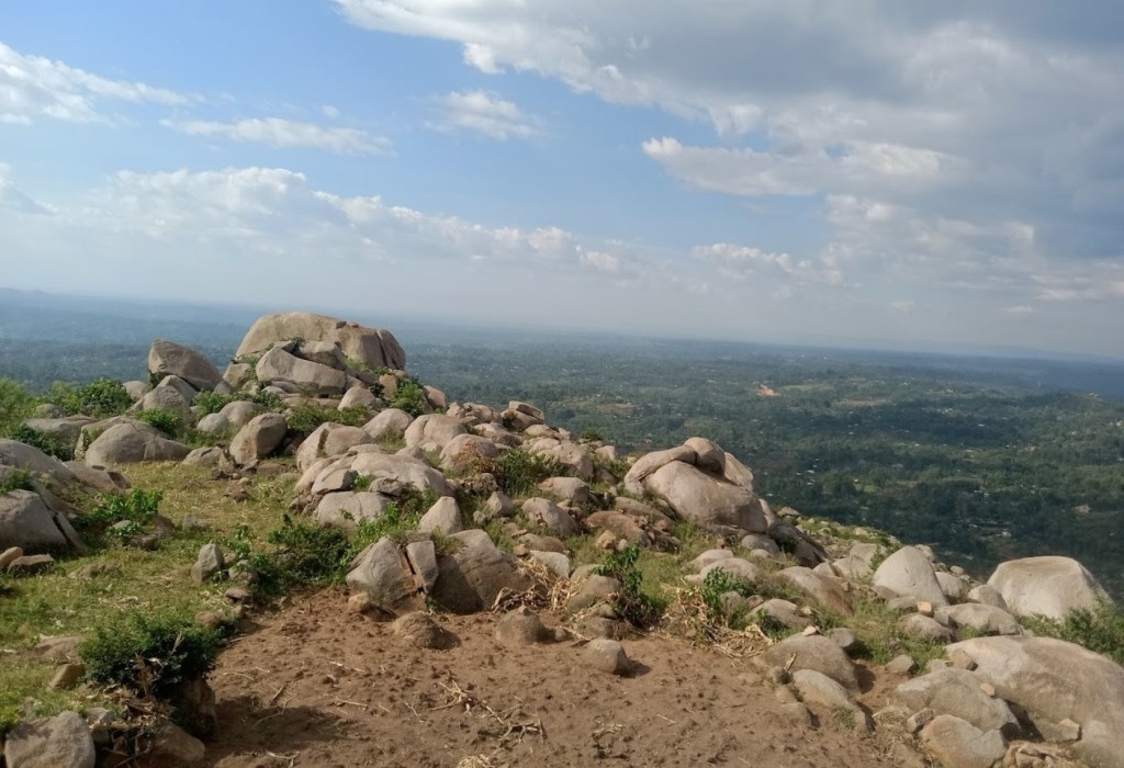
In the west it is traveresed by B1 Kisumu-Busia Road through Maseno and Luanda. It’s also crossed down the middle by A1 Kisumu-Kakamega Road via Majengo and Chavakali. The latter, A1 Road, branches out at Gisambai with a feeder road aiming northwest for Mudete. Fabulous scenery en-route especially over the shoulder of Maragoli Hill past Majengo and the contiguous Bunyore Hills. As the name Vihiga suggests, translating to rocks, the area is awash with huge granite rock formations strewn about its picturesque rolling hillscapes. These are an emblematic hallmark.
A trip to Vihiga’s beautiful hills and valleys, many with streams flowing through them, is an unforgettable experience of splendid sights. On the higher reaches of these hillsides are views of Kisumu and Lake Victoria in the distant background. One of the intangible attractions in Vihiga County is emphatically the sprightly cultural diversity. Vihiga County is, of course, home to the Maragoli tribe, a sub-groups of Luhya, who on rites and rituals are one of the unique cultures in Kenya. Mungoma Cave, deep in Maragoli Hills, is said to be the Maragoli’s original home.
And by the same token, Vihiga County is also recognized for its corresponding cultural celebrations and rich traditional music and dance, including the Isukuti dance. The county celebrates Maragoli Cultural Festival every December, which brings together people from the Luhya community to honor their culture through dance, storytelling, and traditional ceremonies. The region has notable historical sites as well, such as the Kaimosi Mission established by Quaker missionaries in the early 20th century, and the Maragoli Hills which holds spiritual significance.
Despite challenges related to population density and infrastructure, Vihiga County continues to develop through initiatives in education, healthcare, and agriculture. Although still underdeveloped for tourism, Vihiga County is a beautiful destination for those interested in Kenya’s cultural and ecological diversity. All in all, Vihiga is known for its agricultural productivity, especially tea and subsistence farming. Tea plantations, particularly in the Kaimosi area, add to the county’s natural beauty.
Salient Features of Vihiga County
- County Number 38
- Area – 531 km2
- Altitude – 1300 to 1800 ms
- Major Towns – Luanda, Mbale, Maseno, Serem
- Borders – Nandi, Kakamega, Siaya, Kisumu

Typified by lush, green landscapes with rolling hills, rivers, waterfalls and forest, such as the much-noted Nganyi and Kaimosi Forests, which offer scenic spots for nature exploration and birdwatching, Vihiga County is famous for its agricultural productivity, especially tea and subsistence farming. Despite challenges related to population density it continues to thrive as a hotspot for farming and tourism.
You Are Here: Vihiga County
Where to Next?
Explore Destinations in Vihiga County
A Guide to Vihiga County


A Summa Digest of Vihiga

About Vihiga Way Back When

26 Attractions in Vihiga County, arranged as one would visit these - south, west, east then west - with aid of in-depth narratives, images, strip maps and distance chart:

Nganyi Rainmakers Forest, Roddy's Green Lounge, Bunyore Hills, Mbale, Kima Stone Mountain, Kima Church of God, Mwitoko Fish Farm, Kidundu Friends Church, Maragoli Hills, Mungoma Caves, Givavei Cave, Givavei Artisans, Jesus Wagevere Rock, Chabuga Mausoleum, African Divine Church, Obida Ombima Mill, Sosa Cottages, Mudete Tea Factory, Magnum Resort, Turaco Intercounty Resort, Kaimosi Forest, Kaimosi Mission Wildlife Conservancy, Kakamega Forest, Kibiri Forest, River Yala, Kichutu Gold Mine

Know More About Vihiga County: Its Geography, Land-Use, Highlights, Population, Roads - including a distance chart, Airports, Climate & National Monuments

What’s The Air Like In Vihiga?
Vihiga experiences a high equatorial climate with well distributed rainfall year-round. Temperatures range between 14ºC and 32ºC.


What’s The Lay Of The Land in C.38?
Generally speaking, Vihiga slopes gently from west to east – with undulating hills and valleys plying streams flowing from northeast to southwest, all draining into Lake Victoria as the mouth.
