
Natural Landmarks in Samburu


Mathews Range: The Misty Samburu Montane
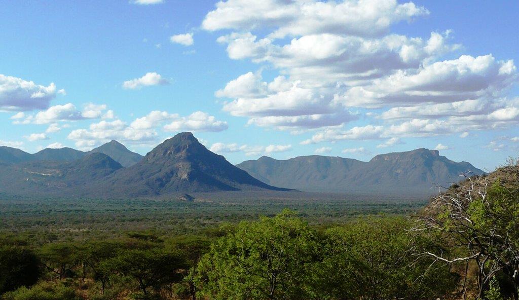
As you leave Archer’s Post, in the south of Samburu County, the anticipation of adventure and beautiful landscapes is palpable. Shortly, the splendorous Mount Ololokwe comes into view, rising in the distance. About 30 km beyond Archer’s Post northbound, the iconic Mount Olokokwe is dead center ahead, imposing and glorious, along a straight section of the A2 Road seemingly designed to aim for the mountain. To the side of this photogenic landmark, layered in the background, is a series of jagged peaks in the horizon, about 50 km out; these are the much-talked about but rarely visited Mathews Mountain Range more proper the Lenkiyio Hills.
The splendid Mathews Range runs for 150 km from the mid area of Namunyak Conservancy southerly trending into Kalama Conservancy, oriented in a north to south strike. The range is typified by a steep topography and granite outcrops that render much of the area inaccessible. The highest point, at Warges Peak, rises to 2,688 ms. The forest cover is lionized for being in the best condition of all the sky island forests in Northern Kenya thanks to its remoteness and steep rugged terrain which preclude easy access. So too do the cultural prohibitions or compatible use of the forest. The forest was gazetted in 1956 and rebranded as a reserve in 1964.
At the time of the initial gazette order, the forest was recorded as approximately 97.4 km2 of which 25% was closed canopy forest, 50% mixed forest and 25% was shrub or grassland. Dubbed Lenkiyio Hills, Mathew’s Range is a rich biodiversity hotspot that stakes a claim as one of the most beautiful in Kenya. As a roadside attraction, views of the Mathews Range are exceptional at the western-end of the all-weather C79 Archer’s Post-Wamba Road that travels astride the boundaries of Namunyak Conservancy (south) and Kalama and Westgate Conservancies (north), over the Mathews Range, to drop down into Wamba town. Mathews Range offers gratifying scenery and abundance of adventure at Kitich Camp and Sarara Camp.

Kenya is blessed with a diverse range of natural landmarks, showcasing the country’s stunning landscapes and rich biodiversity. These natural landmarks represent Kenya’s breathtaking beauty and ecological diversity, making it a top destination for safari adventures, outdoor, and wilderness exploration.
Index of Natural Landmarks Around Kenya


Baringo County - Paka Volcano, Metkei Ridge, Tugen (Kamasia) Hills, Silale Crater, Bomet County - Motigo Hill, Bungoma County - Kabuchai Hills, Luucho Hills, Busia County - Samia Hills, Namenya Hill, Namenya Hill, Elgeyo Marakwet County - Kerio Valley, Elgeyo Escarpment, Mektei Ridge, Cherangani Hills, Embu County - Karue Hill, Kianjiru Hill, Mumoni Hill, Garissa County - Merti Plain, Homa Bay County - Asego & Kasarua Hills, Ruri Hills, Gembe Hills, The Gwassi Hills, Kanyamwa Escarpment, Isiolo County - Merti Plateau, Nyambene Range, Mlima Tatu Kula Mawe, Kajiado County - Ngong Hills, Mount Suswa, Ol Doinyo Orok, Chyulu Hills, Kericho County - Tinderet Mountain, Kiambu County - Kijabe Hills, Kilifi County - Marafa Gorge, Kisumu County - Kajulu Hills, Kitui County - Yatta Plateau, Laikipia County - Laikipia Plateau, Makueni County - Nzaui Range, Mandera County - Dandu Hills, Marsabit County - Mount Nyiru, Nabuyatom Cone, Mount Kulal, Mount Marsabit, Hurri Hills, Sololo Escarpment, Mount Forore, Meru County - Kierra Ridge, Mount Kenya, Nakuru County - Mount Longonot, Eburru Mountains, Menengai Crater, Nandi County - Nandi Hills, Nyando Escarpment, Kamulat Hill, Nandi Scarp, Narok County - Nguruman, Loita Hills, Siria Ridge, Nyamira County - Kibugat Hill, Emanga Hills, Kiabonyoru Hill, Nkoora Hill, Nyandarua County - Aberdare Range, Mount Kipipiri, Samburu County - Scared Mount Ololokwe, Ndoto Mountain Range, Mathews Range, Mount Nyiru, Samburu Hills, Loroghi Plateau, Siaya County - Got Ramogi, Taita Taveta County - Taita (Range) Hills, Mount Sagalla, Ngulia Hills, Mount Kasigau, Tharaka Nithi County - Kijegge Range, Turkana County - Mogila Hills, Loima Hills, Vihiga County - Bunyore Hills, Maragoli Hills, Wajir County - Mansa Guda Range, Malabar Hill, West Pokot County - Mount Murpus, Koh Hill, Sekerr Range


Samburu County, in northern Kenya, offers stunning landscapes, rich cultural heritage, and unique wildlife. Known for its stunning mountains, hills, remote wilderness, traditional Samburu culture, and less-visited national reserves, the county provides an authentic experience away from the popular safari circuit.
You Are Here: Mathews Range
Where to Next?
Explore Destinations Nearby Mathews Range
A Guide to Samburu County


A Summa Digest of Samburu

About Samburu Way Back When

50 Destinations in Samburu County, arranged as one would visit these - south, north, west then south - with aid of narratives, images, strip maps and distance chart:

Shaba National Reserve, Buffalo Springs National Reserve, Ashnil Samburu Camp, Archer's Post, Chanler’s Falls, Umoja Cultural Village, Nashipa Eco Camp, Lion's Cave Camp, Samburu National Reserve, Samburu Sopa Lodge, Samburu Intrepids Camp, Ewaso Lions, Kalama Conservancy, Saruni Samburu Lodge, Westgate Conservancy, Rhodia Mann Museum, Meibai Conservancy, Mount Ololokwe, Namunyak Community Conservancy, Sarara Camp, Singing Wells, Reteti Sanctuary, Mathews Range, Kitich Camp, Sera Conservancy, Saruni Rhino Camp, Ndoto Mountains, Mlima Tatu, Ngurunit, Ngurunit Rock Pools, Camp Ndotto, Mount Nyiru, Desert Rose, El Barta, Samburu Hills, Baragoi Deanery, Nachola Site, Napong Hills, Losiolo Escarpment, Emuruangogolak, Kirisia Forest, Ngari Hill Lodge, Maralal Safari Lodge, Yale Camp, Maralal Camel Derby, Kenyatta House Maralal, Loroghi Plateau, Engare Narok Sanctuary, Lake Mbaringon

Know More About Samburu County: Its Geography, Land-Use, Highlights, Population, Roads - including a distance chart, Airports, Climate & National Monuments

What’s The Air Like In Samburu?
Samburu is almost always hot! The driest months are January and February. The mean annual temperature is 29oC, with fast blowing winds especially on the lowlands. Rain is temporal and erratic.


What’s The Lay Of The Land In C.25?
Over 80% of Samburu lies within the fragile arid to semi-arid ecological vast block of Kenya. Altitude, excepting the ranges and mountains, varies from 2040 ms to 600 ms asl.
