
Viewpoints in Nyandarua
Gitwe Viewpoint: The Unsung Rift Valley Vista
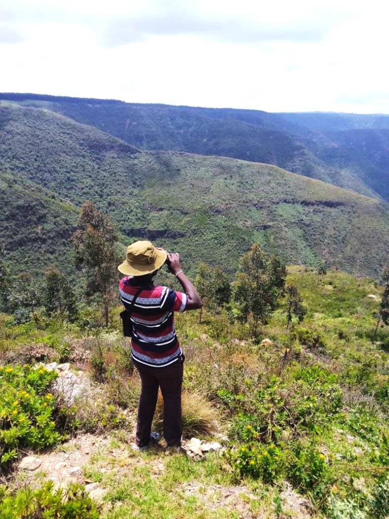
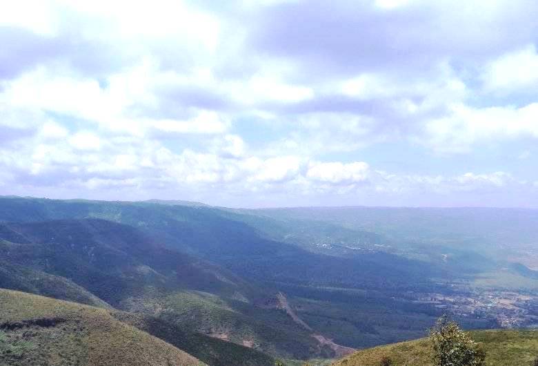
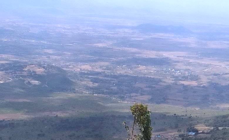
The Gregory Rift Valley, in Kenya traversing south to north, is full of breathtaking viewpoints that offer stunning landscapes and incredible vistas. The most popular and widely cited of these of the Great Rift Viewpoint beyond Limuru, liked for its convenience just on the shoulder of the A104 Nakuru-Nairobi Road and, of course, the views. For those who have been here frequently, there’s a reasonable chance they’ve pondered on what is around the corner beyond the bluff that wends away from the viewpoint. It is a rarely unsung viewpoint, offering a different outlook of this unrepeatable sight of the Gregory Rift Valley, simply dubbed Gitwe Viewpoint.
It is 83 km to Gitwe Viewpoint from the main business district of Nairobi via the A104 Nairobi-Nakuru Road to Magumu, then a detour away from the A014 for 2 km through the countryside, passing the little known Matches Dam en route. It is situated about 500 ms before Mawingu Camp Kenya, the new paragliding outfit offering flights over the area. Gitwe Viewpoint is undeveloped, lacking a safety barries and demarcated paths for walking. The clearing is sufficient enough during the dryer month but can be daunting after the rains. Still, the view is unique, with fetching panoramas of Mount Longonot, Kijabe Hill and a wide view valleyscape. Even the journey there, passing through bucolic farms and rural-side, is stunning.

From stunning views of the Great Rift Valley to serene coastlines, Kenya is blessed with breathtaking viewpoints that offer travelers unforgettable panoramas. These destinations not only provide amazing photo backdrops but also inspire awe and appreciation for the natural world. Showcasing the diversity and beauty of our planet, these viewpoints are sure to leave an indelible mark on your journey.
Amazing Viewpoint Around Kenya


Busia County - Kakapel Rock, Embu County - Karue Hill, Riakanau Viewpoint, Elgeyo Marakwet County - Iten Viewpoint, Nyaru Viewpoint, Kolol Viewpoint, Homa Bay County - Lambwe Valley, Kisii County - Keroka Landscape, Kitui County - Ikoo Valley Viewpoint, Nzambani Rock, Kwale County - The Elephant Lookout, Laikipia County - Mukutan Ridge, Machakos County - Kanzalu Thui Stone, Makueni County - Makongo Viewpoint, Thwake Dam Viewpoint, Meru County - Kierra Ridge, Mwonyo Valley, Nakuru County - The Great Rift Valley Viewpoint, Elementaita Viewpoint, Menengai Viewpoint, Nandi County: Nandi Rock, Tabolwa Rock, Ketbarak Viewpoint, Nyamira County - The Emanga Ridge, Nyandarua County - Gitwe Viewpoint, Heni Viewpoint, Kinangop Plateau, Samburu County - Ngurunit Valley, El Barta Plains, Malaso (Losiolo) Viewpoint, Taita Taveta County - Vuria Hill, Lion's Bluff, Mudanda Rock, Shetani Lava, Mzima Springs, Chaimu Crater, Salaita Hill, Tharaka Nithi County - Kierra, Nithi Bridge Viewpoint, Trans Nzoia County - Endebess (Elephant) Viewpoint, West Pokot County - Kapkoris Hill Viewpoint, Kaisagat Viewpoint, The Marich Pass Centre, Turkwel Gorge


Greatly positioned as an agrarian hub, with increased investment in infrastructure, Nyandarua County is also famous for its scenic landscapes and montane climate. Named after the Aberdare Ranges, with an extensive presence, Nyandarua grew as an agribusiness locale but is well making a name for itself as an alpine escape.
You Are Here: Gitwe Viewpoint
Where to Next?
Explore Destinations Nearby Gitwe Viewpoint
A Guide to Nyandarua County


A Summa Digest of Nyandarua

About Nyandarua Way Back When

45 Destinations in Nyandarua County, arranged as one would visit these - south, north then west - with aid of in-depth narratives, images, strip maps and distance chart:

Matches Dam, Gitwe Viewpoint, Mawingu Camp Kenya, Heni Viewpoint, Kijabe Hills, Kinangop Step, Ragia Forest Trail, Sasumua Dam, Sharpe's Longclaw Nature Reserve, Elmer Resort & Spa, Cheese House, Njabini, Elephant Hill, Aberdare Range, Kinangop Plateau, Mount Kipipiri, Mount Kipipiri Golf & Resort, Wanjohi Valley (Happy Valley), Davida Getaway, Wanjohi Falls, Kenungu Falls, Buxton House, Rurimeria Forest Trail, Mount Satima, Table Mountain, Dragon’s Teeth, Cedar Retreat (Log Cabin), Ndaragwa Falls, Ndaragwa Forest, Maverick Camp Rondavels & Farmstay, Malewa Bundu Camp, Plovers Eco Camp, Dundori Forest, Lake Ol Bolossat, Samawati Conservancy, Olrok Farm House, Laikipia Plateau, Tafaria Castle & Center for Arts, The Fairway Residence, Carnegie House (Ngobit Girls School), Knessiah Jewish Synagogue, Thompson Falls

Know More About Nyandarua County: Geography, Land-Use, Highlights, Population, Roads - including strip maps, Airports, Climate & National Monuments

What’s The Air Like, Nyandarua?
Thanks to its high altitude, all of Nyandarua experiences pleasant to low temperatures. Highest temperatures are in the month of December that bears an average temperature of 25oC: Lowest in July, 14oC.


What’s The Lay Of The Land In C.18?
To the east, the Aberdare Range traverses its border with Nyeri County. End to end, the Aberdare Range, with vast presence in Nyandarua is a whooping great 565 km.
