
Reservoir Dams in Muranga


Mathioya Dam: Powering Mathioya
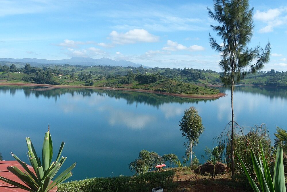
Having arrived at Muranga town along either entry of the C71 road, via Kabati-Maragua-Muranga Road or Sagana-Muranga Road, the traveller is entitled to explore many places of interest in the county, not to miss the Aberdare Ranges where delightful fishing camps and lodges are sited. About 4 km west of the main Muranga town, via Manyeki Road through Gatheru, lies Mathioya Dam, which is a part of KenGen’s Wanjii Power Station. Commissioned in 1952, this is a run-of-river system dam with a small reservoir holding low water storage capacity.
Its dams the self-same Mathioya River creating a pretty reservoir worth your visit. Mathioya and Maragua rivers have their headwaters on Aberdare Forest. Wanjii station has a total capacity of 7.4MW. Units 1 and 2 are each rated at 3MW and get their run-off water from Mathioya River through a wide tunnel about 5 kms long that runs under Muranga town. The water from the turbines then flows into Maragua River. Units 3 and 4 are fed by Maragua River. A project to update and upgrade the units was awarded to Voith Hydro Germany. Site installation work was planned to begin in July 2019. This project will indubitably prop its capacity.

Kenya has several reservoir dams that play a consequential roles in water supply, hydroelectric power generation, irrigation, flood control, and other water-related activities. The most famous of these are Seven Forks Dams along the Tana River. While reservoir dams are critical infrastructure projects that contribute to Kenya’s economic development, they are also visually stunning go-to destinations.
Index of Dams in Kenya


Baringo County - Chemususu Dam, Kirandich Dam, Bungoma County - Chwele Dam, Muyayi Dam, Makhonge Dam, Kabuchai Dam, Elgeyo Marakwet County - Kimwarer Dam, Arrow Dam, Chebara Dam, Embu County - Gitaru Dam, Kamburu Dam, Masinga Dam, Kiambere Dam, Kindaruma Dam, Kajiado County - The Kiserian Dam, Kericho County - Chemusot Dam, Dimbolil Dam, Londiani Dam, Kiambu County - Ruiru Dam, Thika Dam, Kirinyaga County - Thiba Dam, Kwale County - The Mukurumudzi Dam, Nyalani Dam, Machakos County - Maruba Dam, Makueni County - The Mulima Dam, Mannoni Dam, Katilini, Ndukuma Dam, Thwake Dam, Migori County - Kebharisia Dam, Muranga County - The Ndakaini Dam, Maragua Dam, Mathioya Dam, Nairobi County - Nairobi Dam, Nyamira County - Bonyunyu Dam, Nyandarua County - Matches Dam, Sasamua Dam, Nyahururu Dam, Nyeri County - Chinga Dam, Wanjii Dam, Uasin Gishu County - Kesses Dam, Two Rivers Dam, West Pokot County - The Turkwel Gorge Dam


Murang’a County is a rich agricultural and cultural hub, known for its historical significance, beautiful landscapes, and important role in Kenya’s tea and coffee industries. The scenic hillscapes and cultural heritage makes Murang’a County a fascinating destination for visitors interested in nature, history, and agriculture.
You Are Here: Mathioya Dam
Where to Next?
Explore Destinations Nearby Mathioya Dam
A Guide to Muranga County


A Summa Digest of Muranga

About Muranga Way Back When

40 Destinations in Muranga County, arranged as one would visit these - south, north, west then east - with aid of narratives, images, strip maps and distance chart:

Gatura Greens Purple Tea Farm Tours, Kimakia Tea Cottage, Kimakia Falls, Kanunga Falls, Ndakaini Dam, Ndakaini Dam Marathon, Muchiri's Resort, Aberdare Forest, Elephant Hill, Aberdare Bongo Ecolodge, Ranges View Lodge, Manguyo Falls, Mathioya River, Kenya Fly Fishers (Southern Camp), Aberdare Cottages and Fishing Lodge, Mathioya River Lodge, Karuri Gakure Grave Site, Tuthu Catholic Church, Mukurwe Wa Gathanga, Karia Ka Mbari Ya Ngware, Wangu Wa Makeri Shrine, C70 Gacharage-Kangema Road, Maragua Dam, Maragua Falls, Old A2 Route, Muranga town, Kakuzi Boran Barn, Makuyu Golf Club, Makuyu Ridge, Eco Farmhouse, Muranga Gorges, Mathioya Dam, Muranga (St. James & All Martyrs) Church, Stanley’s Haven, Sagana Getaway Retreat, Tetura Sagana Camp, Laibon Gardens & Campsite, Jangwani Camp

Know More About Muranga County: Its Geography, Land-Use, Highlights, Population, Roads - including strip maps, Airports, Climate & National Monuments

What’s The Air Like In Muranga?
Maximum temperatures ranges between 26°C and 30°C, while the minimum ranges between 14°C and 18°C. In the western area, which is mostly high altitudes, the minimum temperatures can be as low as 6°C in July.


What’s The Lay Of The Land In C.21?
The topography and geology of Muranga is more or less sloping westerly towards the long Aberdare Range, the rain catchment from where most of rivers draining it originate. All these rivers flow south-eastward bound, to join Tana.
