
A Beach, Safari, Culture Hub


A Summa Digest of Kwale County
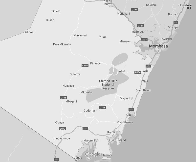
The plumb-bob shaped Kwale County, aptly taking up the southernmost trigonal nib-end of Kenya, is flanked by the Kenya-Tanzania border and the Indian Ocean. The county can be divided up into three cognate ecological zones: coastal plain, foot plateau and Nyika plateau. The coastal plain, rarely exceeding 5 km in width landwards, generally lies below the 100 feet contour line. This harbours the azure waters and palm-fringed white powder beach at Diani, along part of the 512 km coastline of Kenya, which is so well known as to warrant little introduction here.
Diani is a part of Kwale County’s 91 km long coastal plain liked for its four prime beaches: Tiwi-Mwachema River-Diani-Galu Beach (15 km), Gazi Beach (2.5 km), Msambweni Beach (4.5 km) and Shimoni-Wasini Island-Funzi Beach (8 km); all developed with lovely resorts. The seaward margin of these beaches is sheltered by a coral reef which, in its natural state, supports the shallow coast, ergo masses of sand, eroded coral and decayed material transported from elsewhere, washed up inshore by pared-down waves, with a weak backwash, over eons, have piled up to form the salubrious sandy haven that is a sun and sand mecca year round.
Behind the coastal plain the land rises in rapidity, and often more or less abruptly, to the foot plateau that stands between 200 and 450 feet. As you move further inland, from the sandy coastal plain, the soils get more fertile and deeper taking on a sandy loam profile that is red in colour. These red soils have an important effect on farming and, it is generally found that, mangoes and coconuts are grown in bounty on the fertile loams to the west and cashew nuts on the eastern region.
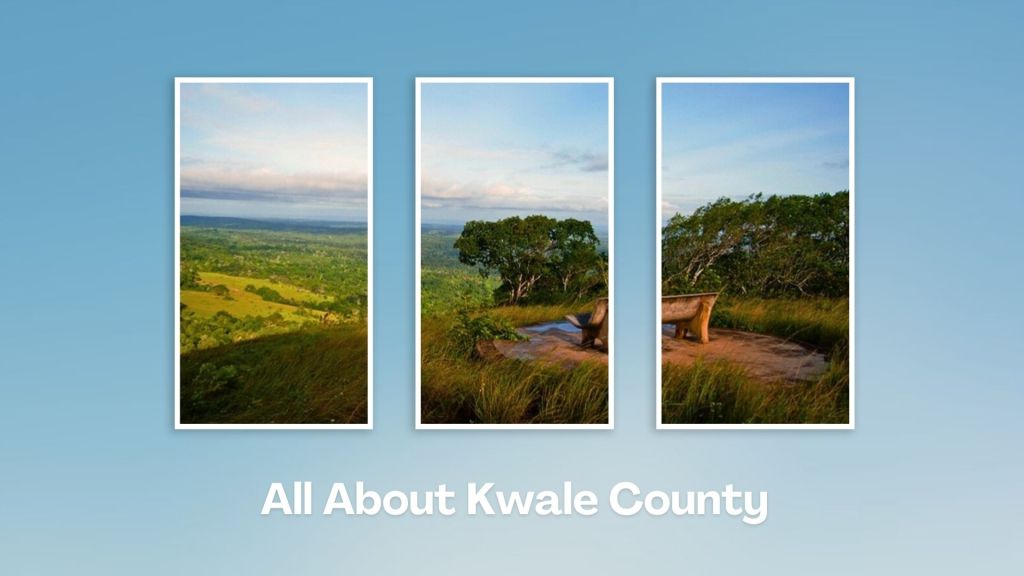
Large coconut plantations flourish on the north and south mainland, particularly near Gazi, while further south are the Ramisi Sugar farms. In the northern part of the generally planed-off surface of the foot plateau, the land takes a steep ascent at Shimba Hills (1,640 feet). This horst-like eminence forms the dominant natural landmark in Kwale County. Apart from a few isolated summits – Tsimba (1,148 ft), Mrima (1,060 ft) and Dzombo (1,250 ft) – the highest of which attains an altitude of just about 1,600 feet, the range is more or less level at a height of around 1,200 ft.
From the northern edge of the foot plateau [range] the terrain drops steeply into the torrid Nyika, which, starting from about the 1,000 feet contour, loses altitude to about 600 feet. The Nyika is semi-arid, sporadically populated and capable of supporting only dwarf, scrubby, generally leafless trees and succulent plants.
Presently, the lovely beach at Diani has been the most successful at attracting travellers to Kwale, yet, there’s much more to the county than the miles of perfect beach. About 50 km west of this widely-famous beach, known for its soft white sands, turquoise waters, and water sports like snorkeling, kite surfing, and diving lies Shimba Hills National Reserve. A haven for wildlife and one of the few places in Kenya to spot the rare sable antelope, the reserve offers stunning views of the coastline. This makes Kwale County unique and singular as the only place you can easily enjoy beach and safari with little difficulties, travel, and advance planning.
For the history buff, Kwale County is awash with a series of historic sites, found mainly along the coastal plain, many of them on private lands; consisted of ruins, ancient mosques, palaces, houses, split walls with gates and tombs. Owing to their isolation and overgrown vegetation, most are exacting to locate. Moreover, the Mijikenda communities, particularly the Digo, who inhabit the coastal plain and the Duruma, particularly around Gazi and Vanga, offer surpassing cultural passages into their age-old traditions. There is also a marked Arab influence.
In general, the population density decreases westwards, this being primarily due to the inland diminution in rainfall and, to a lesser extent, the presence of rock outcrops and their harsh effects on the growth of vegetation. The principal line of communication in Kwale County is the B8 Road. It runs from Malindi to Mombasa (B8) and thence southwards to Lunga Lunga as the A14, running along the centre of the coastal plain throughout much of its course. Communication is also made fairly easy with regular flights from Nairobi and Malindi landing at Ukunda Airport.
Salient Features of Kwale County
- County Number 02
- Area – 8270 km2
- Altitude – 1390 ft
- Major Towns – Kwale, Diani, Ukunda
- Borders – Mombasa, Taita Taveta, Kilifi, Tanzania
Located along the Kenyan coast, and a hub renowned for its pristine beaches, rich cultural heritage, and breathtaking landscapes, Kwale County uniquely combines two of Kenya’s unsurpassed offerings – beach and safari. Kwale County is also a melting pot of coastal traditions, modern development, farming and trade to boot.
You Are Here: Kwale County
Where to Next?
Explore Destinations in Kwale County
A Guide to Kwale County


A Summa Digest of Kwale

About Kwale Way Back When

85 Destinations in Kwale County, arranged as one would visit these - north, south, east then south - with aid of in-depth narratives, images, maps and distance chart:

Shelly Beach, Time Out Art Camp, Mwaluganje Elephant Sanctuary, Kutazama Lodge, Mandhari Lodge, Kimerimeta Safari Lodge, Baraza Park, Kwale Town, Shimba Hills National Reserve, Shimba Hills Lodge, Elephant Lookout, Sheldrick Falls, Shimba Hills Organic Farm, Nyalani Dam, WWF Nursery, Tiwi Beach, Diani-Chale Marine National Reserve, Kongo Mosque, Twiga Mosque, Diani Mosque, Diani Beach Art Gallery, Diani Bikes, Center Point Mall, Diani Beach, Almasi Art Agency, Diamond Leisure Beach & Golf Resort, Ali Barbour’s Cave Restaurant, Kenya Kite Masters, Kite Festival, Funguo Wreck, Swahili Beach Resort, Raydon Water Sports, Colobus Conservation Trust, Sails Beach Bar & Restaurant, H2O Extreme, Nomad Beach Bar & Restaurant, Baobab Beach Resort, Lantana Galu Beach, Galu Ruins, Bora Bora Wildlife Park, Skydive Diani, Kalista Bar & Restaurant, Kaya Kinondo (Forest), Kinondo Kwetu (Resort), Chale Island, Tulia Eco Garden, Gazi Beach, Gazi Mangrove Boardwalk, Gazi Ruins, Msambweni Beach, Munje Beach, Munje Beach Villas, Munje Ruins, Munje Octopus Closure, Funzi Island, Shirazi Ruins, Fikirini Caves, Hormuz, Pongwe, Shimoni Caves, Betty's Camp, Shimoni Ruins, KWS Shimoni Cottages, Wasini Island, Wasini Ruins, Wasini Boardwalk, Charlie Claw’s, Chambocha Cemetery, Wasini Dolphin Tours, Pilli Pipa Dhow, Blue Monkey Cottages, GVI Mkwiro, Mwaozi Tumbe's Gravestone, Kisite-Mpunguti Marine Park, Sii Island, Mrima Hill, Maji Moto Springs, Vumba Kuu, Vanga, Vanga Ruins, Nyika Plateau

Know More About Kwale County: Its Geography, Land-Use, Highlights, Population, Roads - including strip maps, Airports, Climate & National Monuments

What’s The Air Like In Kwale?
Kwale has monsoon type of climate marked by hot and dry weather from January to May and cooler temperatures from June to August. Average annual temperatures ranges between 24oC and 30oC.


What’s The Lay of The Land In C.02?
Kwale is widely known for its 35 km long coast, where Diani Beach sits. Inland, the coastal uplands, commonly referred to as Shimba Hills, is a sharp elevation in altitude. The land then steeply falls again into the Nyika Plateau and Tsavo.
