
Unusual Attractions in Kilifi


Hell’s Kitchen: The Spooky Marafa Depression
There are a hatful of places around the Kenya that have an otherworldly, almost surreal quality to them, among these being Marafa Depression, which makes you feel as if you’ve stepped into another world. It is reached 5 km beyond Sabaki River Bridge, taking the turnoff to Magarini-Marafa-Dakacha Road. From here, it is a 31 km drive over an earth surface road to north side of Marafa village, where the Marafa Depression, locally dubbed Nyari, or the place that broke itself, is found.
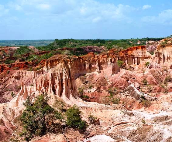
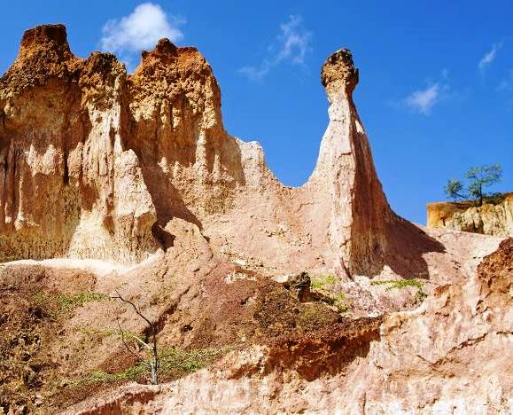
The sight of the fiery crater, with its orange hue glows ominously, is both eerie and mesmerizing, earning it its epithet of Hell’s Kitchen – an ode to the usual heat, too. Marafa Depression is a peculiar landscape, where cirque-shaped pits are formed around narrow ridges where lofty earth pillars, some almost 100 feet tall, many light-coloured, some white to creamy-white, other more orange in outlook, and occasionally with lenticular bands of red and purple clays, rise momentously.
Over its 5 km2 extent a belt of red to orange sands and sandstones form pretty low hills. Along the floor and lower parts, muddy over the rain seasons, are occasionally accompanied by basal pebbles, white or light grey coloured sandy laminated and thin flood deposits overlying the truncated fossil-soil profile at the foot of valley-sides it occupies. The major part of the area is composed of light grey or light yellow coloured sands or silts, underlain by light blue-grey to dark grey or brown coloured clay and overlain by reddish sandy or loamy soils.
“The origins of the Marafa – an extensive erosional scarp north of Marafa village, from which it takes its name of the Marafa Depression is thought to be a land-slide in a cream coloured, argillaceous sandstone in what is now considered part of the late Pliocene – Pleistocene [5 Mya to 12 Mya] along the south side of the Sabaki River at the northern margin of Arabuko Sokoke, to the west of Malindi”.
As a result of the easy erosion of the sediments, the headward progression of a tributary stream of the Koromi breached and drained the depression north of Marafa, in 1948. It seems to be inundated at an occasion of a flood that occurred in 1961. The natural splendor of this 5 km2 steep-sided canyon, curved by eons of flush floods, has left in its wake a picturesque crater with a mars-like appearance.
Its particular combination of erosional configurations, geologic colour and shrubs forms a decorate valley of rare beauty. The striking orange hue contrasts with the blue sky and bushland, creates an otherworldly scene. While it is perfectly safe to explore throughout the day without much to threaten a traveller in the gullies, it is best surveyed during the cooler morning hours before the air gets balmy from noon and afternoon sun. It is located 45 km east of Malindi town in Marafa village.

Around Kenya are a selection of natural landmarks, cultural shrines, architectural oddities, and technological installations that offer incredible, almost surreal experiences that can make you feel as if you’ve stepped into another world. Hauntingly beautiful to some, eerie sights for others, and still, for others, down right strange, these site provide unique experiences for adventurous travelers.
Index of Unusual Attractions Around Kenya


Baringo County - Olduka (Mogotio) Valley, Busia County - The Alupe Leprosy Centre, Elgeyo Marakwet County - Kipteberr, Isiolo County - Magado Crater, Magado Cave Dwellings, Nantudu Spire Rock, Merti Catholic Church, Buffalo Springs, Harr Girrissa, Kericho County - Van Wicker's Cave, The Kipkelion Monastery, Kilifi County - Hell's Kitchen, Luigi Broglio Space Centre, Ngomeni Shipwreck, Kwale County - Three Sisters Caves, Mrima Hills Rare Earth Mine, Laikipia County - Sirmon & Nyariginu Confluence, Lamu County - The Lamu Donkey Sanctuary, Machakos County - Komarock Shrine, Kituluni Magical Hill, Makueni County - Kenze Gorges, Virgin Mary Shrine, Emali Trig, Holy Nzaui Rock, Mandera County - Marehan Sandstone, Marsabit County - Chalbi Desert, Meru County - Mystical Lake Nkunga, The Giant Footprints, Mombasa County - Kizingo, Mbaraki Pillar, Muranga County - Muranga Gorges, Nakuru County - Longonot Earth Station, Menegai, The Djinn House, Diana Caldwell's Shrine, Nandi County - Sheu Morobi Cliffs, Kopere Rocks, Nyandarua County - The Kinangop Step, Wanjohi Happy Valley, Dragon's Teeth, Nyeri County - Italian Memorial Church & Somali Wall, Taita Taveta County - The Taita Skull Caves, Shetani Lava, Yatta Springs, Nyiri Taru Desert, Crystal Caves at Lake Chala, Salaita (Slaughter) Hill, Haunted Sniper's Tree, Turkana County - Kapedo Falls, Lake Alablab, The Turkana Boy Monument, Samburu County - Samburu Singing Wells, Ngurunit Pools & Slides, Mystical Emuruangogolak, Vihiga County - Wagevere Rock, Nganyi Rainmakers Forest, Wajir County - Shaletey Caves


Touring Kilifi County offers a delightful blend of coastal beauty, lovely beaches, cultural richness, natural wonders, and fascinating ancient ruins. Whether you’re seeking pristine beaches, historical sites, or vibrant cultural experiences – or a combination, Kilifi promises a memorable and enriching travel experience.
Your Are Here: Marafa Depression, Hell’s Kitchen
Where to Next
Explore Places Nearby Marafa Depression, Hell’s Kitchen
A Guide to Kilifi County


A Summa Digest of Kilifi

About Kilifi Way Back When

95 Destinations in Kilifi County, arranged as one would visit these - south, north, east then north - with aid of narratives, images, strip maps and distance chart:

Shimo la Tewa Prison, Mtwapa Creek, Mtwapa Ruins, The Moorings, La Marina Restaurant, Jumba la Mtwana, Kikambala Beach, Vipingo Mosque Ruins, Kinuni Ruins, Kuruwitu Conservancy, Neem Tree House, Vipingo Ridge, Chasimba Cave, Kilifi Sisal Plantations, Vuma Cliffs, Old Town Takaungu, Takaungu Creek, Kitoka Ruins, Takaungu House, Beneath the Baobab Festival, Kilifi Creek, Kilifi Bridge, Kilifi Boatyard, Distant Relatives Lodge, Mnarani Ruins, Mnarani Snake Park, 3 Degrees South, Kamili House, Mazingira Park, Bofa Beach, Saltys Kitesurfing Bar & Restaurant, Bush Baby Kilifi, Casa Dalton, Panga ya Saidi Cave, River Rare Geo Park, Arabuko-Sokoke Forest, Mwangea Hills Forest, Watamu Marine National Park, Uyombo Ruins, Rock & Sea Resort, Mida Creek, Sudi Island, Kirepwe Ruins, Watamu Beach, Ocean Sports Watamu, Medina Palms, Hemimways Watamu, A Rocha Eco Lodge & Conservation Centre, Watamu Treehouse, Garoda Beach, Tribe Watersports, Kite House, Local Ocean Conservation, Bio-Ken Snake Farm, Kiburugeni Ruins, Mgangani Ruins, Mida Creek Nature Camp, Gede Ruins, Kipepeo Butterfly Farm, Malindi Museum, Henry the Navigator Monument, Malindi Pier, Malindi Pillar Tomb, Malindi Waterfront Park, Portuguese Chapel, Vasco da Gama Pillar, Malindi Beach, Ndoro Sculpture Garden, White Elephant Sea & Art Lodge, Malindi Crocodile & Snake Farm, Malindi Marine National Park, Malaika Beach Sunbeds & Restaurant, Sawa Sawa Dhow Excursions, Lo Sfizio Coffee Shop, Lennox Art Gallery, Falconry of Kenya, Hanging Gardens, Malindi Golf & Country Club, River Sabaki Delta, Marafa Depression, Dakacha Woodland, Mekatilili wa Menza Site, Mambrui Dunes, Mambrui, Mambrui Tombs, Kibirakani Ruins, Che Shale Hotel Kitesurf Center, Ngomeni Shipwreck, Luigi Broglio Space Centre, The Nyika Plateau, Galana Conservancy, Ngala Mausoleum, Rabai Museum, Kaya Kambe Shrine, Thomas Wakefield Memorial Church

Know More About Kilifi County: Its Geography, Land-Use, Highlights, Population, Roads - including strip maps, Airports, Climate & National Monuments


What’s The Lay Of The Land In C.05?
Kilifi can be split into three zones – the narrow coastal plain, varying in width from 3 kms to 20 km; few coastal hills lying below 30 ms asl, and the Nyika Plateau rising from 100ms to 340 ms asl.

What’s The Air Like In Kilifi?
For the greater part of the year, the climate along the coastal plain is pleasurable, though humid. Temperature ranges between 21C and 30C along the coast, and between 30C and 34C further inland.

