
The Hydropower Giant


A Summa Digest of Embu County
Nestled in the eastern part of Kenya, Embu County stands as a testament to the rich cultural heritage, agricultural prowess, and natural beauty that Kenya has to offer. It is bordered by Tharaka Nithi County to the north, Meru County to the northeast, Kirinyaga County to the west, and Kitui and Machakos counties south.
The lay of land in Embu County varies from low plains to hilly terrain, making it a picturesque destination. Traditional customs and rituals play a vital role in the daily lives of the people, creating a tapestry of traditions, passed down through generations. As it continues to evolve, its unique character and contributions to the nation’s cultural and economic landscape will undoubtedly become greater.
On the map of Kenya, Embu County resembles of a scalene triangle drawn with an unsteady hand with its apex thrust into Mount Kenya; being one five counties in central Kenya whose borders converge at the apex of Mount Kenya at a point with Nyeri, Kirinyaga, Meru and Tharaka Nithi. The imaginary triangle then inclines from apex to base, with Kii and Rupinganzi Rivers on the west separating it from Kirinyaga, and Thuchi River on the east separating it from Tharaka Nithi County.
Within this overall descend are many other rivers which, lower down, debouch into River Tana that eventually drains, after 1,000 km, into Indian Ocean. The principal lines of communication in Embu are B6 Makutano-Embu-Meru Road, crossing it in the northern area from Embu to Kathageri en-route Meru, and B7 Embu-Kitui Road, travelling southerly from Embu via Gachoka, Kiritiri and Kivaa.
At the base of Embu County lies a hot, dry lowland plain. That is to say, the north and south areas of Embu County could be said to be diametrically opposed and noticeably composed of two distinct ecosystems with crosswise agro-climatic variations: The cool, healthy and fertile zone in upper area around Mount Kenya, comprised of Runyenjes and Manyatta, standing out in perennial contrast with the hotter, droughty and lower area, comprised of Mbeere North and Mbeere South.
For which reason, the topography of Embu County varies in gradatim from low plains to hilly terrain, making it, end-to-end, a picturesque destination. The southwest part of Embu is covered by the Mwea Plains. This area has closer affinities with that west of Kitui, persisting at best as a semi-arid terrain. The notable hills, confined to the northern half, are the mosaic of Kiangombe and Kanjiri Hills, separated by a wide valley through which the Tana has cut its path.
Embu County is best-known as the hydropower giant of Kenya, and as a gateway to Mount Kenya National Park. It hosts the nationally germane seven forks hydro electric dam project, which is a series of five major dams constructed along its southern border, along River Tana. The seven forks project collectively contribute 543 MW or 75% of Kenya’s H.E.P installed capacity. River Tana, the recipient of all the drainage in the area, is a notable example of a strike stream having selected for its course within the area a cavernous, wide channel of fairly little resistance.
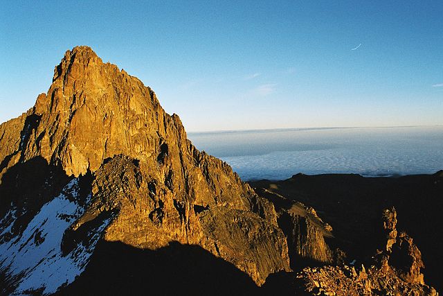
Sighted widely, Mount Kenya is the most conspicuous natural landmarks in Embu County. The major tribe in Embu County is the self-same Embu or Aembu tribe, who, although culturally linked with their neighbours Meru, Tharaka and Kikuyu tribes, have their unique customs. Around the county are more than twenty little-known sacred groves and culturally sites which, aside from their beauty, offer rich insights on Aembu tribe. Embu County has a vibrant and growing cultural tourism scene, with attractions such as traditional ceremonies, festivals, and cultural sites.
Salient Features of Embu County
- County Number 14
- Area – 2818 km2
- Altitude – 515 to 5100 ms
- Major Towns – Embu, Siakago, Runyenges
- Borders – Kirinyaga, Kitui, Machakos, Muranga, Tharaka Nithi, Meru
Situated at the base of Mount Kenya, Embu County offers a rich tapestry of cultural heritage, natural beauty, and adventure activities, making it a rewarding destination for travelers seeking an authentic experience in the central highland of Kenya. Engage with the Aembu and Mbeere people, who inhabit the region, and learn about their traditional way of life, like farming practices, music, and dance.
You Are Here: Embu County
Where to Next?
Explore Destinations in Embu County
A Guide to Embu County


A Summa Digest of Embu

About Embu Way Back When

32 Destinations in Embu County, arranged as one would visit these - south, west, east then south - with the aid of narratives, images, strip maps and distance chart:

Mwea Rice Plains, Ndaraca ya Ngai, Embu Art Centre, Izaak Walton Inn, Iveche Falls, Karunina Falls, Njukiri Forest, Camp Ndunda Falls, Mount Kenya Riverside Retreat, Embu Golf Range, Murinduko Hill Forest, Karue Hill, Kirimiri Forest, Nthenge Njeru Falls, Nthungu Falls, Nthenge Njeru Hiking Trail, Irangi Forest Station, Mzima Fishing Camp, Kaagari-Gaturi Irrigation, Thuci River Lodge, Mbeere Terraces, Kiang’ombe Forest, Mumoni Hill, Kianjiru Hill, Mwea National Reserve, Kamburu Dam, Riakanau Beach, Masinga Dam, Masinga Dam Resort, Gitaru Dam, Kindaruma Dam, Kiambere Dam

Know More About Embu County: Its Geography, Land-Use, Highlights, Population, Roads - with aid of strip maps, Airports, Climate & National Monuments


What’s The Lay Of The Land In C.14?
Embu is exemplified by its sharply defined uplands, lowland and slopes from the north, northwest towards the east and southeast, with a few isolated hills such as Kiambere and Kiang’ombe.

What’s The Air Like In Embu?
Embu has a typical highland profile, on the windward side of Mount Kenya, with cold and wet upper zones to hot and dry lower zones in Tana River Basin. Temperatures range betwixt 20o and 30oC.

