
Farmland Fair-Country


A Summa Digest of Bomet County
Located in southwestern Kenya, Bomet County, relatively small in land surface area, at just 2037 km2, is a geographical crossroads, teetering between the sun-drenched savanna in the south, the verdant forests of the Mau Complex in the east, the famous and prestigious highlands in the north and the healthful tropical Lake Victoria basin in the west.
In the north, Bomet County picks up the undulating topography where Kericho County leaves it off, at Mau Complex. Aside from its north-eastern area that rises easterly to meet the Mau Complex, land in Bomet County generally slopes southward, until it eventually levels out in the flatter terrain nearing Masai Mara National Reserve. The land slopes gently from 3,100 m near the Mau, to 1,800 m in the lower area where the land is mostly flat.
The appeal of Bomet isn’t solely based on the strategic location and homogenic topography, but it also influenced by its climate, natural beauty, accessibility, infrastructure and charming cultures. Rainfall is evenly distributed, except for the short dry season in January and February. The wettest months are April and May. Even so, thanks to its altitude and proximity to the Mau Highland Complex, there is little break between short and long rains across the whole county.
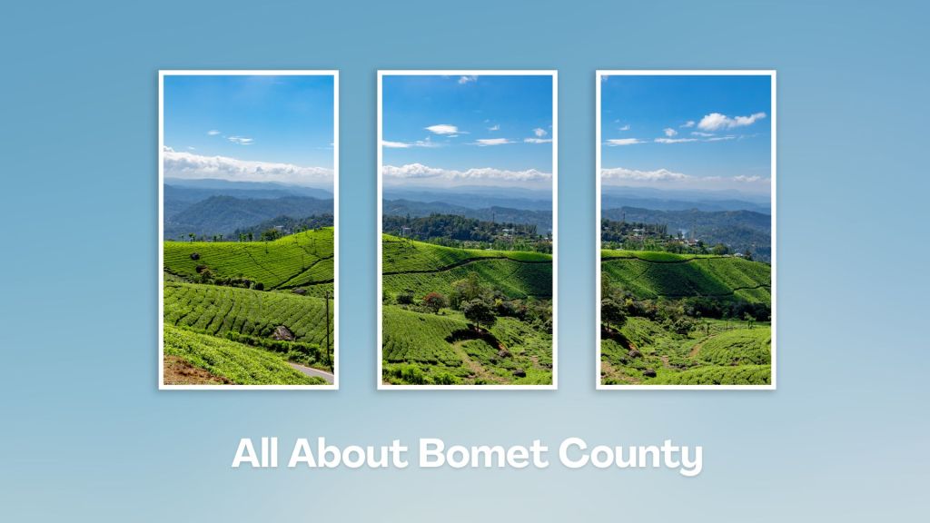
Generally speaking, the temperature levels range from 16o C to 24o C year-round; with the coldest months between February and April. On this account, Bomet’s economy is predominantly based on agriculture, where round about 80% of the residents are farmers. The region is known for tea farming, dairy farming and horticulture. The favorable climate and fertile soils in the area support these agricultural activities, with numerous picturesque tea plantations.
What Bomet County lacks in recognizable touring attractions is made up for by a delightful display of striking agro-climatic zones. The county also has some little-known touring attractions, including natural sites such as Tenwek Falls and the scenic landscapes of the South Rift Valley.
The discerning traveller using, the longer but scenic, B3 Nairobi-Narok-Bomet-Kisii Road quickly apprehends these changes, beginning at Narok’s low-lying wheat fields up to the highland forests at the northern end of Bomet County. The higher area in the north-eastern quarter of Bomet is dominated by tea; its middle region by maize, pyrethrum and coffee, while in the lower-lying southern regions, like Sigor, the main dealing is livestock.
Bomet’s biggest communication advantage is that it is traversed by B3 Nairobi-Kisii Road, crossing it midway from Molut (east) to Sotik (west); a distance of 58 km. The capital town, Bomet, lies almost equidistant from Molut and Sotik. Here, travellers will find plenty of satisfactory accommodation. Bomet town is both the regional hub and a place of relaxation, and naturalness.
Along with the view of the beautiful farms, a visit to the pleasant Tenwek Fall, the Iria Maina Falls, or a walk over one of many hills, are a great way to explore the countryside of Bomet. Other sites of interest in Bomet County include the Trans Mara (beyond the Mara) Forest, which straddles its entire southern boundary, as well as the South Western Mau National Reserve that aligns with Bomet’s northern border; approximately 73 km.
Salient Features of Bomet County
- County Number 36
- Area – 2037 km2
- Altitude – 1800 to 3000 ms
- Major Towns – Bomet, Sotik, Konoin, Kaplong
- Borders – Kericho, Narok, Nyamira, Nakuru
Touring Bomet County offers a chance to explore the lush landscapes, cultural heritage, and natural attractions of Kenya’s Rift Valley region. Whether you’re interested in nature, culture, or adventure, Bomet offers a diverse range of attractions and activities to explore. It is also a jumping-off place to Masai Mara.
You Are Here: Bomet County
Where to Next?
Explore Destinations in Bomet County
A Guide to Bomet County


A Summa Digest of Bomet

About Bomet Way Back When

20 Destinations in Bomet County, arranged as one would visit these - east, north, south then west - with aid of narratives, images, strip maps and distance chart:

Kipsigis Oasis Sanctuary and Culture, Chepalungu Forest, Nogirwet Irrigation Scheme, Chebara Irrigation Scheme, Kaplelach Cultural Centre, Masese Nyangores Ecotourism, Nyangores River, Masai Mara National Reserve, Fair Hills Hotel, Sahara Gardens Hotel, The Willis Hotel, Tenwek Falls, Motigo Hill, Kipsegon Ecosystem, Tirgaga Tea Factory, Trans Mara Forest, South Western Mau Forest, Iria Maina Falls, Changoi Tea Factory

Know More About Bomet County: Its Geography, Land-Use, Highlights, Population, Roads - including a distance chart, Airports, Climate & National Monuments

What’s The Air Like In Bomet?
Rainfall is evenly distributed in Bomet, except for the short dryer season in January and February. Temperature levels range from 16oC to 24oC with the coldest months between February and April; and July.


What’s The Lay Of The Land In C.36?
Bomet has an undulating topography that gives way to a flatter terrain in the south. The overall slope is towards the south, except the north eastern region – which rises eastwards towards the 3,000 ms Mau Mountain Complex.
