
Natural Landmarks in Baringo


Silale Crater
With a summit elevation of 1578m (5013 ft) above sea level, Silale crater has a spectacular summit caldera of 8 long and 5 km wide. The summit walls rise an altitude of about 300m high. The summit is 600-800 m above the surrounding rift valley floor. Silali was formed some 63000 years ago and had its main eruptions around 7050 – 5050 BC.
Although there is still geothermal activity there with some eruptions possibly having happened in the last few hundred years. Geographically, the area is in southern Turkana but administratively, it is at the border of Turkana East and East Pokot counties. The Turkana people call it Silali while the Pokot call it Silale.
It is an area whose ownership is disputed between the Pokot and the Turkana communities, hence frequent fights over pasture. In addition, the Silali area is very rich culturally, being endowed with special archeological sites. The hulking and rocky Mount Silale, or Silale Volcano, within sight of Nakegere Falls, marks the unofficial gatepost to the desiccated Suguta Valley.
Silale and Nakengere, whose location according to maps is in Baringo County, is home to the Turkana. Sugata River, originating from Silale Hills, is a vital lifeline for both man and beast. Silale is situated 70 km north of Lake Baringo, in a very remote area that can only be assessed by four-wheel vehicles or a helicopter.

Kenya is blessed with a diverse range of natural landmarks, showcasing the country’s stunning landscapes and rich biodiversity. These natural landmarks represent Kenya’s breathtaking beauty and ecological diversity, making it a top destination for safari adventures, outdoor, and wilderness exploration.
Index of Natural Landmarks Around Kenya


Baringo County - Paka Volcano, Metkei Ridge, Tugen (Kamasia) Hills, Silale Crater, Bomet County - Motigo Hill, Bungoma County - Kabuchai Hills, Luucho Hills, Busia County - Samia Hills, Namenya Hill, Namenya Hill, Elgeyo Marakwet County - Kerio Valley, Elgeyo Escarpment, Mektei Ridge, Cherangani Hills, Embu County - Karue Hill, Kianjiru Hill, Mumoni Hill, Garissa County - Merti Plain, Homa Bay County - Asego & Kasarua Hills, Ruri Hills, Gembe Hills, The Gwassi Hills, Kanyamwa Escarpment, Isiolo County - Merti Plateau, Nyambene Range, Mlima Tatu Kula Mawe, Kajiado County - Ngong Hills, Mount Suswa, Ol Doinyo Orok, Chyulu Hills, Kericho County - Tinderet Mountain, Kiambu County - Kijabe Hills, Kilifi County - Marafa Gorge, Kisumu County - Kajulu Hills, Kitui County - Yatta Plateau, Laikipia County - Laikipia Plateau, Makueni County - Nzaui Range, Mandera County - Dandu Hills, Marsabit County - Mount Nyiru, Nabuyatom Cone, Mount Kulal, Mount Marsabit, Hurri Hills, Sololo Escarpment, Mount Forore, Meru County - Kierra Ridge, Mount Kenya, Nakuru County - Mount Longonot, Eburru Mountains, Menengai Crater, Nandi County - Nandi Hills, Nyando Escarpment, Kamulat Hill, Nandi Scarp, Narok County - Nguruman, Loita Hills, Siria Ridge, Nyamira County - Kibugat Hill, Emanga Hills, Kiabonyoru Hill, Nkoora Hill, Nyandarua County - Aberdare Range, Mount Kipipiri, Samburu County - Scared Mount Ololokwe, Ndoto Mountain Range, Mathews Range, Mount Nyiru, Samburu Hills, Loroghi Plateau, Siaya County - Got Ramogi, Taita Taveta County - Taita (Range) Hills, Mount Sagalla, Ngulia Hills, Mount Kasigau, Tharaka Nithi County - Kijegge Range, Turkana County - Mogila Hills, Loima Hills, Vihiga County - Bunyore Hills, Maragoli Hills, Wajir County - Mansa Guda Range, Malabar Hill, West Pokot County - Mount Murpus, Koh Hill, Sekerr Range

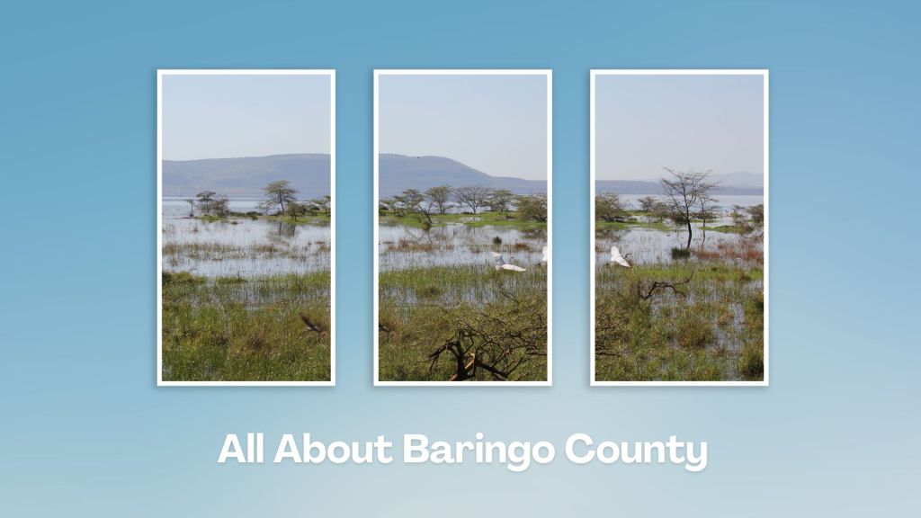
Touring Baringo County offers a unique blend of cultural experiences, natural wonders, and outdoor adventures. Many of its hidden gems, along Kenya’s Rift Valley, create unforgettable memories. Baringo County’s vast ecological gamut is a road-trip lover’s playground, birder’s haven and photographer’s paradise.
You Are Here: Silale Crater
Where to Next?
Explore Destinations Near Silale Crater
A Guide to Baringo County


A Summa Digest of Baringo

About Baringo Way Back When

52 Destinations in Baringo County, arranged as one would visit these - south, north then south - with the aid of narratives, images, strip maps and distance chart:

Mogotio Equator Crossing, Hotel Lomanira, Olduka Valley, Maji-Moto Hot Springs, Lake Bogoria National Reserve, Lake Bogoria Spa Resort, Loboi Plains, Irong Community Conservancy, Chuine Community Conservancy, Laikipia Escarpment, Perkerra Irrigation Scheme, Lake Baringo National Reserve, Kerubo Swamp, Robert's Camp, Royal Doves Garden, Soi Safari Lodge, Teddy Bear Island, Samatian Island Lodge, Ruko Conservancy, Kaptuya Conservancy, Korosi Volcano, Kabarion Conservancy, Paka Volcano, Nakegere (Kapedo) Falls, Mount Silale, Korongoro Hotel, Lomechan Caves, Daraja ya Mungu, Kimalel Goat Auction, Tugen Hills, Katimok Forest, Kabarnet Museum, Kirandich Dam, Morop Hill, Kikojo Falls, Kimng’ochoch Conservancy, Morop-Tarambas Conservancy, Simot Falls, Releng Hot Springs, Kipsaraman Museum, Kolloa Monument, Lake Kamnarok National Reserve, Chebloch Gorge, Kerio Valley National Reserve, Metkei Ridge, Lembus Forest, Eldama Ravine, St. Swithin’s Church, Koibatek Forest Reserve, Chemususu Dam, Timboroa Railway Station.

Know More About Baringo County: Its Geography, Land-Use, Highlights, Population, Roads - including a distance chart, Airports, Climate & National Monuments


What’s The Lay Of The Land In C.30?
Baringo County varies widely in altitude from 700 ms to 3000 ms. One of the prominent features in Baringo is the Kerio Valley, situated in the western and lowest region.

What’s The Air Like In Baringo?
Temperatures vary from region to region in, ranging from 22 to 35 degrees C. Due to its varied altitudes, the sub-counties in Baringo County receive different levels of rainfall.

