
Wildlife Conservancies in Baringo

Irong Community Conservancy
This is Baringo County’s newest Wildlife Conservancy. It spreads over 51 square kilometres northeast of Lake Bogoria National Reserve, atop the well-appointed Irong Hill, and it was created in 2008 when communities in Kapkuikui, Loboi, Kamar and Kaibosoi, in Mochongoi and Emining wards in Marigat and Mogotio Sub-counties, set aside the area as community land.
Irong itself is part of three conservancies – along with Kiborgoch and Chuine Community Conservancies – covering a total of 145 square kilometres that have received direct support of Kshs 2.5 to 3 million each to implement priority projects, from KWCA, which serves as a strategic partner to develop their governance, financial management capacities and provide technical support. Irong is approachable from Marigat by a 20 km drive on B4 Nakuru-Sigor Road and then a short ride of about 5 km, through Kaptim.
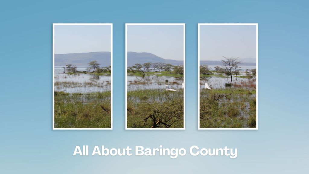
The Irong Hill, from which the Conservancy takes its name, is one the significant highlights, overlooking the drainage and ecosystem of Lake Bogoria National Reserve and Perkerra Irrigation Scheme. Irong Community Conservancy and Kiborgoch wetland conservancy cover two distinct habitats, a gradient sloping from the top of the culturally revered Irong Hill to the wetland. These make a grazing and watering area reserved by community elders for communal use.
The wetlands’ vital role is to retain and moderate the flow of water from the neighbouring rivers. Irong, and especially within its forested areas, is home to a variety of wildlife, ergo part of the reasons for its formation was to safeguard the migratory corridor for the Greater Kudu as well as provide a safe habitat for their growth. Others species sighted here include dik dik, hyrax, waterbuck, zebra, sitatunga, hippo and more than 45 bird species.

Kenya has about 110 wildlife conservancies, all promoting the placid co-existence of local people and wildlife in mutual well-being. Improved security, better land management, income, employment and support to community projects have all encouraged the epic rise of conservancies unique attractions and experiences.
Index of Wildlife Conservancies in Kenya


Baringo County - Kimn'gochoch Conservancy, Irong Conservancy, Ruko Conservancy, Chuine Conservancy, Kaptuya Conservancy, Kabarion Conservancy, Morop Tarambas Community Conservancy, Garissa County - Ishaqbini Hirola Conservancy, Homa Bay County - Gwassi Hills Forest Conservancy, Isiolo County - Biliqo Bulesa Community Conservancy, Leparua Conservancy, Ol Lentille Conservancy, Oldonyiro Conservancy, Nasuulu Community Game Conservancy, Nakuprat Gotu Conservancy, Kajiado County - Rimpa Estate Wildlife Conservancy, Shompole Wildlife Conservancy, Olkirimatian Conservancy, Mount Suswa Conservancy, Sidai Oleng Wildlife Conservancy, Selenkay Conservancy, Kericho County - Chebulu Conservancy, Kilifi County - Kuruwitu Marine Conservancy, Galana Wildlife Conservancy, Kirinyaga County - Ragati Conservancy, Kitui County - Kanyanyoo Conservancy, Laikipia County - Ol Ari Nyiro Conservancy, Loisaba Conservancy, Naibunga Game Conservancy, Ol Lentille Conservancy, Ol Jogi Conservancy, Ol Pejeta Conservancy, Lekurruki Conservancy, Il Ngwesi Conservancy, Lamu County - Kipini Conservancy, Machakos County - The Athi Kapiti Conservancy, Swara Plain Wildlife Conservancy, Makueni County - Kilalinda Conservancy, Marsabit County - Jaldessa Community Conservancy, Shurr Community Conservancy, Songa Conservancy, Melako Conservancy, Mandera County - The Dandu Hills Conservancy, Chachabole Wildlife Conservancy, Rhamu Conservancy, Meru County - Lewa Wildlife Conservancy, Nakuru County - Oserengoni Conservancy, Narok County - The Mara Triangle, Mara North Conservancy, Oloisukut Conservancy, Lemek Conservancy, Olare Motorogi Conservancy, Ol Choro Oiroua Conservancy, Enonkishu Game Conservancy, Pardamat Conservancy, Naibosho Conservancy, Ol Kinyei Conservancy, Ol Derikesi Conservancy, Samburu County - Kalama Conservancy, Westgate Conservancy, Meibai Conservancy, Namunyak Conservancy, Sera Conservancy, Taita Taveta County - Lumo Conservancy, Mbulia Conservancy, The Wushumbu Conservancy, Tana River County - Kipini Conservancy, Ndera East Conservancy, Bura East Conservancy, Vihiga County - Kaimosi Mission Wildlife Conservancy, Wajir County - Sabuli Wildlife Conservancy, Uasin Gishu County - Chebororwa Community Conservancy, Ndalat Hill Conservancy

Touring Baringo County offers a unique blend of cultural experiences, natural wonders, and outdoor adventures. Many of its hidden gems, along Kenya’s Rift Valley, create unforgettable memories. Baringo County’s vast ecological gamut is a road-trip lover’s playground, birder’s haven and photographer’s paradise.
You Are Here: Irong Conservancy
Where to Next?
Explore Destinations Near Irong Conservancy
A Guide to Baringo County


A Summa Digest of Baringo

About Baringo Way Back When

52 Destinations in Baringo County, arranged as one would visit these - south, north then south - with the aid of narratives, images, strip maps and distance chart:

Mogotio Equator Crossing, Hotel Lomanira, Olduka Valley, Maji-Moto Hot Springs, Lake Bogoria National Reserve, Lake Bogoria Spa Resort, Loboi Plains, Irong Community Conservancy, Chuine Community Conservancy, Laikipia Escarpment, Perkerra Irrigation Scheme, Lake Baringo National Reserve, Kerubo Swamp, Robert's Camp, Royal Doves Garden, Soi Safari Lodge, Teddy Bear Island, Samatian Island Lodge, Ruko Conservancy, Kaptuya Conservancy, Korosi Volcano, Kabarion Conservancy, Paka Volcano, Nakegere (Kapedo) Falls, Mount Silale, Korongoro Hotel, Lomechan Caves, Daraja ya Mungu, Kimalel Goat Auction, Tugen Hills, Katimok Forest, Kabarnet Museum, Kirandich Dam, Morop Hill, Kikojo Falls, Kimng’ochoch Conservancy, Morop-Tarambas Conservancy, Simot Falls, Releng Hot Springs, Kipsaraman Museum, Kolloa Monument, Lake Kamnarok National Reserve, Chebloch Gorge, Kerio Valley National Reserve, Metkei Ridge, Lembus Forest, Eldama Ravine, St. Swithin’s Church, Koibatek Forest Reserve, Chemususu Dam, Timboroa Railway Station.

Know More About Baringo County: Its Geography, Land-Use, Highlights, Population, Roads - including a distance chart, Airports, Climate & National Monuments


What’s The Lay Of The Land In C.30?
Baringo County varies widely in altitude from 700 ms to 3000 ms. One of the prominent features in Baringo is the Kerio Valley, situated in the western and lowest region.

What’s The Air Like In Baringo?
Temperatures vary from region to region in, ranging from 22 to 35 degrees C. Due to its varied altitudes, the sub-counties in Baringo County receive different levels of rainfall.

