
Jewel of Natural Beauty


A Summa Digest of Baringo County
Covering an area of 11,015 km2 in western Kenya, encircled by counties with very divergent ecologies and embodying in its gamut the constituent diversity of each, Baringo County is a scenically-splendid destination with a whopping collection of memorable attractions, as unique as they are diverse. A place of natural beauty.
From 3,000 m asl in temperate and pleasant south, a continuum of the Mau Highlands, you gradually lose altitude as you head north, down to 700 m in the arid, sunbaked and desolate jerkwater north. This touches with the low-lying South Turkana National Reserve. Baringo’s contrasting biodiversity, with stretches of thick forests, farmlands, wooded rolling hills, volcanic badlands, wildlife plenty savannas and dramatic cliffs, as you traverse through, wholly justifies its moniker of “jewel of natural beauty” and ranks among Kenya’s popular circuits.
Furthermore, Baringo County is in a great location. The eastern wall of the Great Rift Valley, bounding it on the east, and the Tugen Hills, with the epic north-end of the Elgeyo Escarpment on the west, further lends prominence to its unrepeatable beauty. So much so, Baringo County is on course to become Kenya’s premier Geopark, part of the Great Rift Valley system – a spectacular landscape of steep-fault scarps, deep gorges, cliffs, lakes, craters, gushing geysers, and hot springs. It has two world-famous lakes and breathtaking waterfalls to boot.
The general progress around Baringo County is also encouraging enough to merit enjoyable travels. Its central position in western Kenya and a fairly developed road network makes communication end-to-end relatively easy. Sightseers who prefer to travel in circuits, rather than retrace familiar routes, will find that Baringo County’s major roads makes this easy with little advance preparation.
If, instead of heading west from Nakuru town via A104 Road, one turns north onto B4 Nakuru-Kabarnet-Sigor Road via Mogotio, they will quickly find themselves passing through a fair-land carrying great sceneries, and plenty of hotels.
The temperate and evergreen southern quarter of Baringo County, providing an oasis of serenity amidst forests and farmlands, offers numerous opportunities for sightseeing, walking and eco-tourism, before heading north. The series of forests in the south, whose current and untapped potential for premium sustainable and responsible tourism is too often waxed-lyrical, are a budget friendly alternative.
Having tested your green thumb in the forests, the townships and centres on-circuit are great for fostering cultural exchange and understanding, as you enjoy local roadside treats. En route to Marigat, motorists can take a quick detour to Mogotio Equator Station for an interesting experience standing with one foot in the Northern Hemisphere and the other in the Southern Hemisphere, before heading to Lake Bogoria 45 km away. It is beautiful countryside drive enroute.
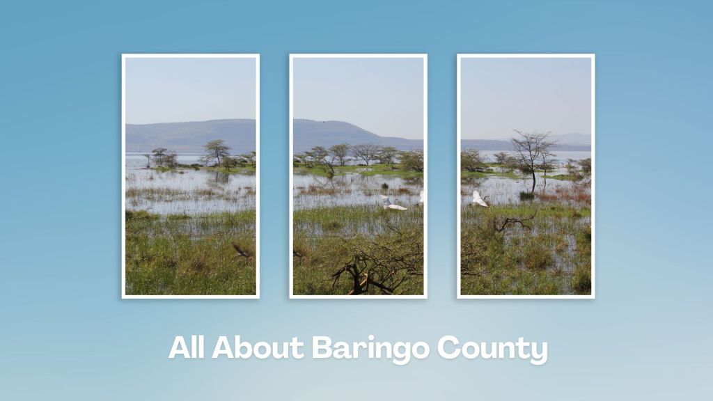
A paradise for walkers and birdwatchers, Lake Bogoria is particularly interesting because it is one of few hot water lakes in the world. The spouts of geysers and hot springs along its banks makes for a rare and indulging experience. Lake Baringo, famous throughout the world for its hundreds of thousands of flamingos and over 470 other bird species, including the African fish eagle, lies 30 km north.
In between the two lakes sits the primitive, unsullied landscape of Loboi Swamp, covered mainly by the lacustrine salt-impregnated silt deposits, separating the considerably incompatible twins – Bogoria being a saline lake while Baringo is a freshwater lake. From Lake Baringo the widely-popular circuit, avoiding the dried-out north, doubles back to Marigat, then into Kabarnet, the capital town.
From Kabarnet town there is the choice to take C54 Kabarnet-Iten-Eldoret Road, a stretch which offers the chance to absorb the striking sights of Baringo County often romanticized in travel handbooks like the lofty Tugen Hills, and Elgeyo Escarpment. To the east, the Kerio Valley presents a superb panorama, with the Kerio River cutting through the whooping great valley floor. The alternate route, Kabarnet-Nyaru-Ravine Road, goes up and over the breathtaking Mektei Ridge.
The less travelled circuit northbound, distance from Marigat to Sigor 174 km, is a hard afternoon’s drive through the torrid and desolate arid patches of Baringo whose rarely captured beauty is beguiling, into West Pokot County. From Sigor it is an equidistant 170 km brill and fascinating drive south to Eldoret town.
End to end Baringo County is home to a rich tapestry of cultures and ethnicities, with the main communities being the Tugen, Ilchamus, Pokot and the Njemps. Each of these groups has a unique way of life, traditional practices and language. The county is a melting pot of many traditions and customs, making it a great destination for those interested in experiencing Kenya’s diverse cultures.
Salient Features of Baringo County
- County Number – 30
- Area – 11,015 km2
- Altitude – 700 to 3000 ms
- Major Towns – Kabarnet, Eldama Ravine, Mogotio
- Borders – Turkana, Samburu, Laikipia, Nakuru, West Pokot, Kericho, Uasin Gishu, Elgeyo Marakwet
Touring Baringo County offers a unique blend of cultural experiences, natural wonders, and outdoor adventures. Many of its hidden gems, along Kenya’s Rift Valley, create unforgettable memories. Baringo County’s vast ecological gamut is a road-trip lover’s playground, birder’s haven and photographer’s paradise.
You Are Here: Baringo County
Where to Next?
Explore Destinations in Baringo County
A Guide to Baringo County


A Summa Digest of Baringo

About Baringo Way Back When

52 Destinations in Baringo County, arranged as one would visit these - south, north then south - with the aid of narratives, images, strip maps and distance chart:

Mogotio Equator Crossing, Hotel Lomanira, Olduka Valley, Maji-Moto Hot Springs, Lake Bogoria National Reserve, Lake Bogoria Spa Resort, Loboi Plains, Irong Community Conservancy, Chuine Community Conservancy, Laikipia Escarpment, Perkerra Irrigation Scheme, Lake Baringo National Reserve, Kerubo Swamp, Robert's Camp, Royal Doves Garden, Soi Safari Lodge, Teddy Bear Island, Samatian Island Lodge, Ruko Conservancy, Kaptuya Conservancy, Korosi Volcano, Kabarion Conservancy, Paka Volcano, Nakegere (Kapedo) Falls, Mount Silale, Korongoro Hotel, Lomechan Caves, Daraja ya Mungu, Kimalel Goat Auction, Tugen Hills, Katimok Forest, Kabarnet Museum, Kirandich Dam, Morop Hill, Kikojo Falls, Kimng’ochoch Conservancy, Morop-Tarambas Conservancy, Simot Falls, Releng Hot Springs, Kipsaraman Museum, Kolloa Monument, Lake Kamnarok National Reserve, Chebloch Gorge, Kerio Valley National Reserve, Metkei Ridge, Lembus Forest, Eldama Ravine, St. Swithin’s Church, Koibatek Forest Reserve, Chemususu Dam, Timboroa Railway Station.

Know More About Baringo County: Its Geography, Land-Use, Highlights, Population, Roads - including a distance chart, Airports, Climate & National Monuments


What’s The Lay Of The Land In C.30?
Baringo County varies widely in altitude from 700 ms to 3000 ms. One of the prominent features in Baringo is the Kerio Valley, situated in the western and lowest region.

What’s The Air Like In Baringo?
Temperatures vary from region to region in, ranging from 22 to 35 degrees C. Due to its varied altitudes, the sub-counties in Baringo County receive different levels of rainfall.

